![]()
CRAVENS FALLS |
|
|
RATING - 20.1
VR - 1.8 (Small) HR - 4.5 SR - 12/20 TYPE OF APPROACH - Bushwhack DIFFICULTY - Difficult LOCATION - Mt. Baker Recreation Area TYPE - Horsetail HEIGHT - 80' WIDTH - 15' GPS - N48 42.947 W121 50.460 ELEVATION - 4295' |
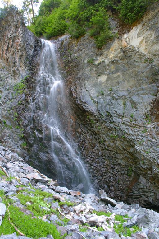 Cravens Falls occurs
where an unnamed branch of Rocky Creek drops around 80' over an amazing cliff of basalt
and lands in a pile of boulders before cascading for another 30' or so. The trip
into the falls is not horribly difficult and the creek is covered with beautiful
wildflowers the whole way up. Cravens Falls occurs
where an unnamed branch of Rocky Creek drops around 80' over an amazing cliff of basalt
and lands in a pile of boulders before cascading for another 30' or so. The trip
into the falls is not horribly difficult and the creek is covered with beautiful
wildflowers the whole way up.To get an easier view of the falls, stay on the trail and climb up towards the Park Butte Lookout. Just before the trail makes its final turn towards the Butte (at around 4 miles), find any of the boot paths that head east along the ridge between Rocky Creek and Pocket Lake. Keep your eyes towards Rocky Creek on the north and eventually you should see the falls. |
| DIRECTIONS - Drive
east along Highway 20 and turn onto the Baker Lake Road. After a few miles, go
across the bridge over Rocky Creek and turn left onto FR 12 when the main road heads to
the right. Take a left at the first fork and then turn right onto FR 13 (signed for
Schriebers Meadows). Take this road to the end at the Schriebers Meadows
Trailhead. Head through the meadows along the trail until after you cross Rocky
Creek. Follow it down for a few hundred feet until you see a side stream coming in
from the right. Follow this creek upstream for about 3/4 of a mile to the
falls, passing Pickpocket Falls on the way. NEARBY WATERFALLS - Pickpocket Falls, Portrait Falls |
|
ADDITIONAL
PICTURES (CLICK TO ENLARGE) |
|
HOME WHATCOM COUNTY LINKS BEST IN THE NW WATERFALLS FOR KIDS FLICKR FACEBOOK STORE |
|