![]()
DE HARO FALLS |
|
|
RATING -
44.0
VR - 6 (Med) HR - 6 SR - 8/20 TYPE - Tiered HEIGHT - 200' WIDTH - 15' TYPE OF APPROACH - Bushwhack DIFFICULTY - Extremely Difficult LOCATION - Middle Fork Nooksack Road GPS - N48 45.279 W121 54.384 ELEVATION - 3241' |
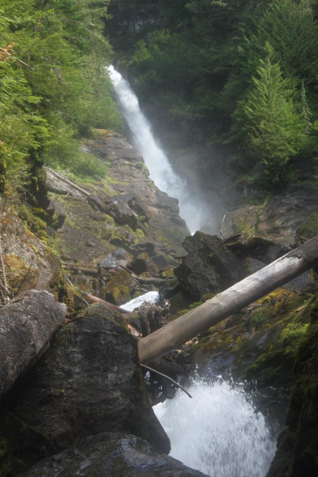 Wallace Creek is a large creek in
the Middle Fork Nooksack Valley. The creek appears to harbor four waterfalls.
The uppermost of these falls appears from satellite imagery to be a sheer
plunge high on the slopes of Mt. Baker. De Haro Falls is the second,
and probably largest waterfall on the creek. Wallace Creek is a large creek in
the Middle Fork Nooksack Valley. The creek appears to harbor four waterfalls.
The uppermost of these falls appears from satellite imagery to be a sheer
plunge high on the slopes of Mt. Baker. De Haro Falls is the second,
and probably largest waterfall on the creek.Wallace Creek shoots out from the cliff face and plunges around 100' before immediately turning and dropping another 15'. Below this, the creek continues to cascade for another 100' or so which could legitimately be added to the height. This section is absolutely covered with logs and debris so it's not the prettiest area. Getting to the falls involves an extremely difficult bushwhack that I can't recommend to anyone. Mt. Baker was named for Lt. Joseph Baker of George Vancouver's ship. However, the first European to document the mountain was Gonzalo Lopez de Haro, two years earlier. Since he was robbed of naming the mountain, the least we can do is give him a waterfall. This will also help avoid confusion with Wallace Falls off Highway 2. |
|
DIRECTIONS - Follow the directions to
Lower Wallace Creek Falls. De Haro Falls is located about 2 miles
upstream but it is an extremely tough trip. It took me 9 hours
roundtrip and I could barely walk the next day. My advice is leave
this one alone. NEARBY WATERFALLS - Halhomish Falls, Lower Wallace Creek Falls, Middle Wallace Creek Falls, Warm Creek Falls |
|
|
VIDEO |
|
HOME WHATCOM COUNTY LINKS BEST IN THE NW WATERFALLS FOR KIDS FLICKR FACEBOOK STORE |
|