![]()
DOCK BUTTE FALLS |
|
|
RATING - 32.0
VR - 3.6 (Med/Sm) HR - 5 SR - 14/20 TYPE OF APPROACH - Bushwhack DIFFICULTY - Very Difficult LOCATION - Baker Lake Road TYPE - Tiered HEIGHT - 120' WIDTH - 10' GPS - N48 38.147 W121 46.204 ELEVATION - 1750' |
Below the falls the creek continues to run through a series of bedrock slides and cascades all the way to Middle Dock Butte Falls. In fact, I believe the entire run through the canyon may be bedrock based so if someone wanted to call it one long waterfall I would have a hard time arguing with them. About halfway between the two waterfalls a tributary creek drops over a really pretty, 120' tall horsetail. I can't confirm whether this is just an ephemeral stream or runs year round so I will have to investigate further in the future to find out for sure. I couldn't get a clear enough view of this tributary waterfall for pictures but it was really pretty. There is a second overgrown road that crosses (or used to cross) the creek about 800' downstream from the lower falls so one could make a loop trip out of the canyon and avoid having to climb back up the steep hills. This will be my route of choice when I return to the area. This lower road is pretty messy but it's better than having to climb back up 400' of super steep hills. |
| DIRECTIONS -
You probably need a GPS for this one. Follow the directions to
Middle Blue Lake Falls. Continue
along the road for three more switchbacks. Leave the main road and
take an overgrown road off the corner. Follow this soggy,
brush-covered road until you hear the creek on your left (maybe 1/2 a mile).
Leave the road and climb down the ridge until you hear and eventually see
the falls. NEARBY WATERFALLS - Lower Dock Butte Falls, Middle Dock Butte Falls |
|
VIDEO
|
|
| HOME/a> SKAGIT COUNTY LINKS BEST IN THE NW WATERFALLS FOR KIDS FLICKR FACEBOOK STORE | |
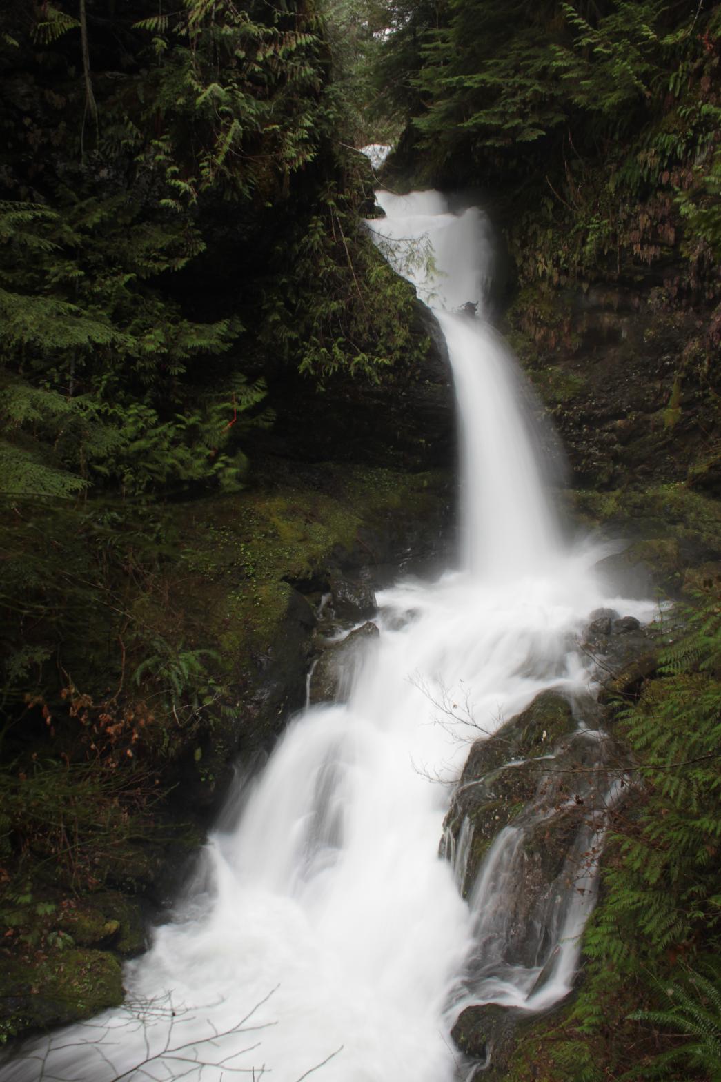 This
creek begins its life near Dock Butte. About halfway to its
convergence with Bear Creek it runs through a very impressive canyon.
As it enters the canyon it drops over this cool and impressive waterfall.
The falls begin with a 14' tall fan-shaped drop (it looked a lot taller than
that so I'll have to re-measure if I go back). The creek then slides
through a trough and launches outward in a 36' tall plunging drop similar in
appearance to Ponytail Falls in the Columbia River Gorge. The falls
continue with sliding drops of 18', 30', and 20' before finally flattening
out. I had seen no documentation of this waterfall prior to my visit,
but there were pink ribbons all over the area including in the bowl at the
base of the falls so somebody knows about it. The creek was absolutely
raging on my first visit and it made access and photography difficult.
At the bottom of the 30' slide the creek was slamming into a rock or log (so
much water I couldn't see what it was hitting) and exploding upward.
The explosion would go over 20' tall at times and reminded me of the ocean
surf crashing into a rocky shore. Pretty cool. I suspect at
normal flow the waterfall is much easier to explore around and take pictures
of.
This
creek begins its life near Dock Butte. About halfway to its
convergence with Bear Creek it runs through a very impressive canyon.
As it enters the canyon it drops over this cool and impressive waterfall.
The falls begin with a 14' tall fan-shaped drop (it looked a lot taller than
that so I'll have to re-measure if I go back). The creek then slides
through a trough and launches outward in a 36' tall plunging drop similar in
appearance to Ponytail Falls in the Columbia River Gorge. The falls
continue with sliding drops of 18', 30', and 20' before finally flattening
out. I had seen no documentation of this waterfall prior to my visit,
but there were pink ribbons all over the area including in the bowl at the
base of the falls so somebody knows about it. The creek was absolutely
raging on my first visit and it made access and photography difficult.
At the bottom of the 30' slide the creek was slamming into a rock or log (so
much water I couldn't see what it was hitting) and exploding upward.
The explosion would go over 20' tall at times and reminded me of the ocean
surf crashing into a rocky shore. Pretty cool. I suspect at
normal flow the waterfall is much easier to explore around and take pictures
of.