![]()
HADLEY FALLS |
|
|
RATING - 32.0
VR - 4 (M/Sm) HR - 6.5 SR - 6/20 TYPE OF APPROACH - Trail DIFFICULTY - Medium LOCATION - Cougar Divide Trail TYPE - Horsetail HEIGHT - 200' WIDTH - 25' GPS - N48 49.928 W121 48.730 ELEVATION - 4750' |
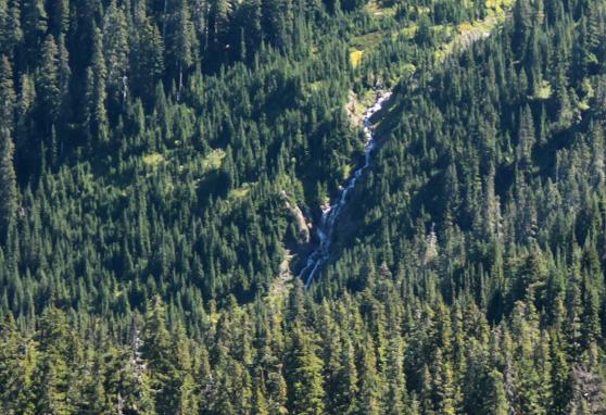 Hadley
Falls is a fairly impressive waterfall located near the headwaters of Dobbs
Creek (I've seen it spelled Dodds as well). The waterfall drops
somewhere in the vacinity of 200' along an unnamed, although fairly large
volume stream. When I first saw the waterfall I was surprised at how
steeply it dropped. From the aerial images I assumed this was a much
more shallow, cascading waterfall. Hadley
Falls is a fairly impressive waterfall located near the headwaters of Dobbs
Creek (I've seen it spelled Dodds as well). The waterfall drops
somewhere in the vacinity of 200' along an unnamed, although fairly large
volume stream. When I first saw the waterfall I was surprised at how
steeply it dropped. From the aerial images I assumed this was a much
more shallow, cascading waterfall.The waterfall can be seen for much of the length of the Cougar Divide Trail once it breaks out of the woods. A close-up view should be possible and the bushwhack does not look too difficult from the end of the trail. I hope to revisit the trail and get to the base of the falls later this year; I was limited on time the first trip into the area. From the trail, this adds a nice touch to the overall scene, but from up close this looks to be a fairly major waterfall. |
| DIRECTIONS - Drive out Mt. Baker Highway and turn onto Wells Creek Road (FR 33), signed for Nooksack Falls. Follow the road to its end in about 10 miles. It gets very rough after crossing Bar Creek about 6 miles along. Hike the amazing Cougar Divide Trail. In a little over two miles the trail will break out of the woods for good and reach the amazing Cougar Divide. Hadley Falls can be seen for well over a mile of the trail by looking south and slightly down. | |
HOME WHATCOM COUNTY LINKS BEST IN THE NW WATERFALLS FOR KIDS FLICKR FACEBOOK STORE |
|